|
Unit 3 -- Meteorology, Oceans,
Oil and Mineral Exploration
"For many environmental applications, remote sensing is the best means of acquiring basic information, particularly on a regional scale and repetitive schedule."
Summary of Chapters in This Part
Chapters 9, 10, 11
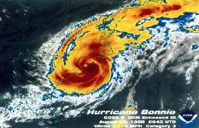
Remote sensing can be used for many different applications. It is being used to predict the weather, understanding many different aspects of the ocean, monitoring waste and oil spills, measuring rainfall and wind patterns.
Remote sensing is also being used for oil and mineral exploration. Images can be used to map mineral deposits and discover new places that contain oil deposits. Remote sensing has played an important role in discovering oil in places like Sudan using the Landsat MSS images. Many different types of highly sensitive remote sensing techniques are being used to find new mineral deposits in places that are difficult, such as vegetated areas that contain rock.
Remote sensing can be applied to and aide many different areas by providing highly specific and detailed images.
Useful Outside Links, Readings, etc.
A site that provides images of different types of Thermal IR satellite data and what each different image is used for. The site also has good links to other types of remote sensing weather imaging.
A page that provides detail about Seasat and also contains Seasat images to view.
A brief article about how RADARSAT images were used to find an oil spill that was taking place. The article also provides a RADARSAT image and a brief explanation of what you are seeing in the image.
A article about the advances the remote sensing has made in the area of oil exploration.
The Landsat Program: an article about the Landsat program and the advances it had made for people, such as geologists and meteorologists.
A page about the remote sensing system and what is had done for mineral exploration in Australia.
|
|